
Arcadia
Arcadia, a pastoral and agricultural district and a former village, is situated on the Goulburn River, and is 12 km north-east of Murchison. The village was on the Goulburn Valley railway line.
The name came from the Arcadia pastoral run (1839) of about 32,400 ha, on the Goulburn and Broken Rivers. The run was presumably named after Arcadia in Greece, a place with plentiful pasture and water. In 1869 Arcadia was recorded in Bailliere's Victorian gazetteer as a small pastoral hamlet, set in rich grassy flats, well timbered with box, cherry and woolly gum.
After the area was opened for farm selection schools were opened at Arcadia (1877), Arcadia East (1883) and Arcadia South (1889). Arcadia was described in the 1903 Australian handbook:
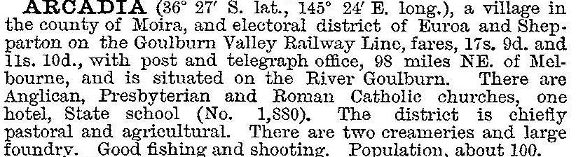
The village at the height of its activity, probably around 1910, had two stores, a hotel (delicensed in the 1940s), wine shop, butter factory, butcher, bootmaker, blacksmith, Anglican, Presbyterian and Catholic churches and a railway station. A hall was built in 1926. Scarcely any of these remained in the 1980s. Arcadia school's populations of 55 (1924) and 11 (1955) provide an explanation. It finally closed in 1982. Arcadia East and Arcadia South schools closed in 1892 and 1919 respectively.
Arcadia's census populations have been:
| Census date | Population |
|---|---|
| 1891 | 172 |
| 1911 | 372 |
| 1961 | 207 |
| 2006 |
659* |
| 2011 | 227 |
* Arcadia and environs
Further Reading
C.W. Halsall, 100 years of local government 1880-1980: a general history of Euroa and district, Local Government Centenary Celebrations Committee, 1980