
Coimadai
Coimadai is a rural locality 10 km north of Bacchus Marsh and 48 km north-west of Melbourne. It is immediately west of Merrimu Reservoir and is situated in the valley formed by the Pyrete or Coimadai Creek which drains southwards from the Lerderderg hills. The creek valley provides the route for the Bacchus Marsh-Gisborne Road.
It is thought that the name is derived from an Aboriginal word describing an old male kangaroo at rest.
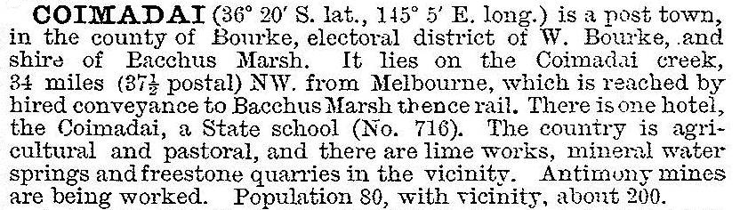
Coimadai school was opened in 1862. The Pyrete Creek had intermittent antimony mining which caused the population to fluctuate. The original village was on a flat area and had a hotel, church and a creamery. In addition to the mining there was a limestone quarry and magnesium springs. Coimadai was described in 1903 in the Australian handbook:
A hall was opened in 1925 and was destroyed by fire on the morning after the Antimony Ball in 1937.
In 1969 the Merrimu Reservoir was completed, inundating the village. The school was above the western edge of the reservoir. There are extensive remnants of the limestone kilns, one of which operated until the 1950s. Limestone was extracted for agricultural purposes until the next decade, when the land was resumed around the Merrimu Reservoir.
The primary school had 53 pupils in 2014.
Coimadai’s war memorial, avenue of honour and recreation reserve are on the road to Diggers Rest.
Coimadai’s census populations have been:
| Census Date | Population |
|---|---|
| 1871 | 87 |
| 1911 | 296 |
| 1961 | 120 |
| 2011 | 404* |
* including Merrimu and environs
Further Reading
Coimadai lime kilns, Rural Water Commission of Victoria, 3 vols, 1986