
Kinglake District
The Kinglake district lies north and south of the dividing range, from east of Whittlesea to Toolangi. It is in the range of 45 to 55 km north-east of central Melbourne. Large parts of the district are the Kinglake National Park.
Kinglake villages
Kinglake is 46 km north-east of Melbourne in the Kinglake Ranges, part of the Great Dividing Range. The area is extensive, and includes Kinglake West, Central, and East. These villages are on the Whittlesea-Kinglake Road, distributed over a distance of about 15 km.
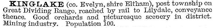
The earliest industries in the area were alluvial gold mining and timber getting – the first gold discovery was Moore's Rush in 1861. In 1878 Alexander Kinglake, historian and surveyor, marked a track from St Andrews across the ranges to Glenburn, and his name was given to Kinglake. After the gold discoveries settlers began clearing the timber. The Kinglake primary school was opened in 1879, and schools at Kinglake West and Kinglake Central were opened in 1896 and 1898. Some massive trees grew in deep soil, and the cleared land yielded good crops of stone fruit, pome fruit and berries. Competition from Tasmanian berry processing caused berry growers to be replaced by potato farmers after World War I. Kinglake was decribed in the 1903 Australian handbook:
Although not as famed as the Dandenong Ranges for views and fern gullies, the Kinglake district nevertheless had some tourist trade and guesthouses. In 1928 the Kinglake National Park was proclaimed, shortly followed by some subdivisions for farmlets. Timber milling had a relatively long life, and some mill workers took up farming as the mills closed. There were timber tramways from Kinglake and Flowerdale to Whittlesea railway station (1911-26).
By 1940 potato growing predominated, orchards being confined to around the small Kinglake township. During the postwar years until 1980 the Kinglake district's population fell, but by 1991 the earlier figure was nearly regained. The loss arose from the amalgamation of small holdings, and the gain from Kinglake's later proximity to the metropolitan fringe.
On 7 February 2009 an exceptionally fierce bushfire swept through the Kinglake Ranges, engulfing all the Kinglake villages, along with houses on bush blocks and ridges. Over 500 houses were destroyed and 42 people lost their lives. The Anglican and Catholic churches, the Middle Kinglake primary school and Kinglake kindergarten were also lost.
The Kinglake community showed remarkable persistence to recover. A temporary village was erected in a few months for families who had lost their houses, and the churches and the school continued in temporary buildings. A large children’s centre was opened in 2011 in Kinglake. Enrolments at the primary schools have been:
| Primary school enrolments | 2011 | 2014 |
|---|---|---|
| Kinglake West | 115 | 168 |
| Middle Kinglake | 115 | 68 |
| Kinglake | 66 | 65 |
Public facilities are distributed among the three villages:
Post office, shops, hotel, Catholic church (Kinglake); memorial reserve, Anglican church, hall, children’s centre (Kinglake Central); Uniting church and mechanics’ institute (Kinglake West).
The census populations of all the Kinglake localities have been:
| Census date | Population |
|---|---|
| 1911 | 382 |
| 1954 | 653 |
| 1991 | 584 |
| 1996 | 691 |
| 2001 | 1814 |
| 2006 | 3251 |
| 2011 | 2694 |
Pheasant Creek
The three Kinglake villages are located about on the ridge line of the dividing range. Between Kinglake West and Kinglake Central there is Pheasant Creek. It has never had a school, but has a post office (1902), a rural supplies store, a general store, an industrial estate and rural/residential housing. Its census populations have been:
| area | census date | population |
|---|---|---|
| Pheasant Creek | 1933 | 93 |
| 1954 | 121 | |
| 1961 | 128 | |
| Pheasant Creek and environs | 2011 | 251 |
Clonbinane and Glenburn
North of the dividing range there are the thinly populated districts of Clonbinane and Glenburn.
Clonbinane is east of Wandong, 55 km north of central Melbourne. It was named after the Clonbinane pastoral run (1843), itself named after a place in County Cork, Ireland. It has had a school and a post office, both temporarily closed at one stage or another. They operated from 1875-1948 and 1892-1956 respectively. The terrain is hilly and remote, like Murchison in north-east Victoria, and like Murchison had prisoner of war camps in the 1940s. The ranges were used for timber cutting, and the Comet Mill, Harrys Nose Road, is heritage listed. Clonbinane has a fire station and its census populations have been:
| area | census date | population |
|---|---|---|
| Clonbinane | 1911 | 84 |
| 1921 | 23 | |
| 1933 | 86 | |
| Clonbinane and environs | 2011 | 381 |
Glenburn is on the Melba Highway, 25 km south of Yea. It was named after the Glenburn pastoral run (1843), although its school (1902) was known as Woodburne for the first three years. Glenburn has a fire station and a public hall, and its census populations have been:
| area | census date | population |
|---|---|---|
| Glenburn | 1911 | 79 |
| 1921 | 115 | |
| 1933 | 100 | |
| 1947 | 152 | |
| 1961 | 134 | |
| Glenburn and environs | 2011 | 360 |
The median age of residents at the 2011 census was 49 years (Victoria 37 years) and farming accounted for 12% of employment.
Humevale and Strathewen
South of the dividing range are Humevale and Strathewen.
Humevale is midway between Whittlesea and Kinglake West. It was originally known as Scrubby Creek, a stream which joins the Plenty River near Whittlesea showground. Scrubby Creek had tenant farmers and paling splitters who worked the Mount Disappointment range to the north. Scrubby Creek school opened in 1875, continuing until 1891. In 1898 a village settlement occasioned the opening of a second school in a hall. There were several orchards until the 1930s, when they were replaced by livestock grazing.
The school (1898-1968) and the post office (1925-59) were renamed Humevale in the 1920s. Hamilton Hume, the explorer, encountered and named Mount Disappointment in 1824, 8 km north of Humevale. He later found a pass through the range and reached Port Phillip, and his name is given to the range around Mount Disappointment. Humevale is in the southern vale of the range. Humevale has part of the Kinglake national park, the Whittlesea golf club and a rural/residential housing area.
Its census populations have been:
| area | census date | population |
|---|---|---|
| Humevale | 1911 | 97 |
| 1921 | 117 | |
| 1947 | 129 | |
| 1961 | 134 | |
| Humevale and environs | 2011 | 370 |
Strathewen is between Arthurs Creek and Kinglake Central. Although it has not had a census count of more than 200 people it shot to prominence on 7 February 2009 when the Black Saturday bushfires destroyed the hall, the firestation, the school and 80 houses. Twenty-three residents died. A new school and hall were built. Strathewen primary school had 37 pupils in 2014.
Strathewen's fertile slopes had been used for orcharding until 1949 when fires destroyed the area.
Castella
Right on the dividing range's ridge line there is Castella, 4 km west of Toolangi. It is on the Yea River, a tributary of the Murray-Goulburn River. The primary school (1917-28) was built on land donated by Miss E. Castella, and presumably the family name was given to the locality. There was also a post office (1918-65).
Castella is mostly lightly timbered country. It has a quarry and a recently improved public reserve (Castella Central Park). Census populations have been:
| area | census date | population |
|---|---|---|
| Castella | 1921 | 47 |
| 1933 | 37 | |
| Castella and environs | 2011 | 344 |
Further Reading
Alan Marshall, Pioneers and painters: one hundred years of Eltham and its Shire, Thomas Nelson, 1971
David A. Johns, A day like no other: Black Saturday on the Kinglake Ranges, 2009
Vivien Achia (ed), Photos in a bowl: stories from Kinglake before and after the disastrous fires of Black Saturday, February 7 2009, Kinglake, 2010