Burrumbeet
Burrumbeet is a rural village on the Western Highway, adjoining the northern shore of Lake Burrumbeet and 20 km north-west of Ballarat.
It was named after the Burrumbeet pastoral run, taken up by the Learmonth brothers in 1838. The run incorporated the Learmonths' Scottish baronial homestead at Ercildoune, near the middle of the property and 7 km north-west of Burrumbeet. The distance indicates the extent of the pastoral run before it was subdivided, and parts excised for the towns of Burrumbeet, Learmonth and Waubra. It is thought that 'Burrumbeet' was derived from an Aboriginal word meaning muddy water.
Burrumbeet's first school was Presbyterian and opened in 1857. Burrumbeet was situated in an agricultural and pastoral district, mostly flat with volcanic cones and pockets of very fertile soil. The town had a post office and a mechanics' institute, and the district had seven hotels according to Bailliere's Victorian gazeteer (1865). The railway was extended from Ballarat to Beaufort via Burrumbeet in 1874.
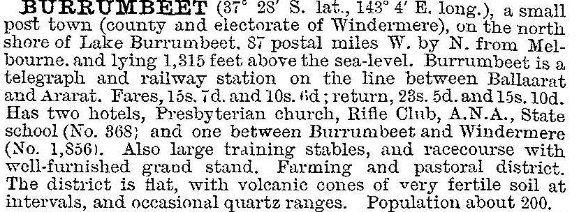
Burrumbeet's best known feature, its racecourse, was formed by the Burrumbeet Park and Windermere Racing Club in 1893. In 1903 Burrumbeet was described in the Australian handbook:

Burrumbeet has become a local recreation venue with its New Year's Day race meeting, the ski and boat club on Lake Burrumbeet, a recreation reserve and a caravan park. The village had a hotel, public hall and general store. The school closed in 1985.
The Lambton Arms Hotel in Burrumbeet, which served the Western Highway trade for many decades, closed its doors in 2014 because the freeway duplication went within a few metres of its front door.
Burrumbeet's census populations have been:
| area | census date | population |
|---|---|---|
| Burrumbeet | 1871 | 150 |
| 1911 | 278 | |
| 1961 | 242 | |
| Burrumbeet and environs | 2011 | 158 |
Further Reading
James H. Mitchell, Progress in the Shire of Ballarat, the shire, c1972
Ken James, Muddy water: a history of Burrumbeet, Camberwell, 2007


