Skipton
Skipton, a rural township, is at the junction of the Glenelg Highway and Mount Emu Creek, 48 km south-east of Ballarat. It is situated toward the northern edge of Victoria’s sheep grazing Western District.
A pastoral run was occupied in the Skipton area in 1838, and a homestead or hut that was built beside the Mount Emu Creek became the site of Skipton. Its location coincided with two tracks to the Western District. A town was surveyed in 1852 and a hotel was built in 1858. Skipton gained notoriety by forming a pastoral association in 1859 and running Western District shows until 1873 when Ballarat took over. The shows helped to establish Skipton as a centre for fine wool.
It is thought that the town was named after Skipton, Yorkshire, England: the old English Scip-tun means sheep town. Both Skiptons also have a town named Linton nearby.
The proprietor of one of the pastoral runs, Francis Ormond, was to become a Presbyterian and educational philanthropist, and he was involved in the opening of a Presbyterian church in 1857. The replacement building (1871) is on the Victorian Heritage Register. Its Russell Hall (1918) was the benefaction of George Russell, another pioneer pastoralist.
Until the 1890s Skipton’s population barely exceeded 150 people, but it gained a school (1864), a Methodist church (1865-70), a mechanics’ institute (1880) and a Catholic church (1897). Closer-settlement farms were then subdivided from pastoral estates and there was soldier settlement after World War I.
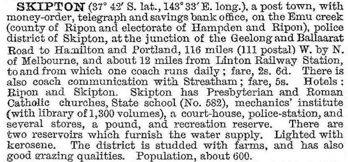
In 1903 Skipton was described in the Australian handbook:

Skipton is situated on Western District plains, and the foregoing description omits mention of tree planting in the town which began in the 1880s and ended with cypress tree plantings to commemorate the Australian Imperial Force in 1914-18.
The increased settlement induced a spur railway line from near Scarsdale to Skipton (1918-85). A bush nursing hospital was opened in 1925. It was replaced in 1963, the new building being opened by the local grazier and Victorian Premer, Henry Bolte.
Skipton has a golf club, a bowling club, a recreation reserve, a swimming pool, Anglican, Catholic and Presbyterian churches, a hospital with aged care, a primary school (93 pupils, 2014) and a public hall. The shopping centre includes a hotel and a small supermarket. The court house (1857) is on the Victorian Heritage Register and the ‘Carraballoc’ homestead and farm buildings (1843-60s), north-west of Skipton, are on the Australian and Victorian historic buildings registers.
Mount Emu Creek’s headwaters are in the Pyrenees Ranges, north of Skipton.
In September 2010 and again in January 2011 many parts of regional Victoria experienced widespread severe flooding. In Skipton, the town’s creek and Jubilee Park Reservoir overflowed affecting businesses in the main street with over a metre of water including the supermarket, chemist, hotel, garage, Skipton Art Gallery and Pottery, and post office. Floodwater from Mount Emu Creek destroyed Skipton’s wooden footbridge (1931) that ran alongside the town’s main bridge along the Glenelg Highway. Floodwater bisected the town.
Skipton’s census populations have been:
| census date | population |
|---|---|
| 1861 | 121 |
| 1881 | 108 |
| 1901 | 308 |
| 1911 | 590 |
| 1933 | 535 |
| 1954 | 515 |
| 1966 | 536 |
| 1971 | 476 |
| 1986 | 508 |
| 1996 | 453 |
| 2006 | 482 |
| 2011 | 452 |
Further Reading
Bill Anderson, On western lands: a history of the Shire of Hampden (1964-1994), Camperdown, 1996
R.A McAlpine, The Shire of Hampden 1863-1963, Terang, 1963
G.C. Notman, Wherein they people meet (Presbyterian history), Skipton, 1957
G.C. Notman, Out of the past: the story of Skipton 1839-1939, Skipton Progress Association, facsimile, 1978
Skipton sketchbook, Skipton and District Historical Society, 2002
Tales from Skipton and from the settlement districts, Skipton, 2003
Further tales from Skipton and from the districts, Skipton, 2008


