Tahara
Tahara is a rural locality in western Victoria, 39 km west of Hamilton. It was named after the Tahara pastoral run (1838), which was situated on both sides of the Wannon River. It is thought that the name was derived from an Aboriginal word which described a spring, of which there are several in the area.
The Tahara village is on the road between Coleraine and Portland, and the Waterloo Hotel was opened there in about 1865. Farm selections were taken up later in that decade, as the Tahara plateau consists mostly of fertile soil. There were also settlements at Tahara Bridge and Tahara West, and all had schools at various times.
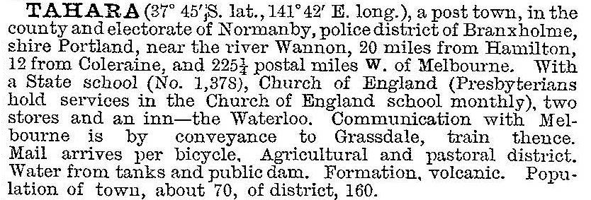
In 1903 Tahara was described in the Australian handbook:

Ten years later a mechanics’ institute, cricket club and a debating society were recorded at Tahara.
Tahara is bypassed by the Henty and Glenelg Highways and the secondary road from Coleraine could not be relied on for much passing trade. The hotel closed in 1922, the two remaining schools were closed in 1949 when a consolidated school was opened at Merino, and the post office closed in 1965.
The Tahara pastoral run was subdivided in 1845, and the head station kept the original name and the outstation was named Murndal. The heritage listed Murndal homestead complex, Murndal Road between Peppers and Brants Roads, includes structures and gardens, 1856-1906.
Tahara’s census populations have been:
| census date | population |
|---|---|
| 1871 | 45 |
| 1901 | 51 |
| 1921 | 206 |
| 1947 | 156 |
| 1961 | 115 |
Further Reading
Gwen Bennett, Watering holes of the west [hotels etc Heywood Shire], the author, 1997


