Colbinabbin
Colbinabbin is a rural district with a village in northern Victoria between Rushworth and Elmore, 140 km north of Melbourne.
Colbinabbin was one of four pastoral runs taken up by Edward Curr in 1844, and was watered by the Cornella Creek and Lake Cooper. Its named is thought to be derived from an Aboriginal word meaning dingo caught in a trap or describing grey and red soil types. (Mount Camel, to the south, has red volcanic soil).
In 1858 the run passed out of Curr’s hands. A group of German settlers purchased farm allotments on part of the run and established a small community. The balance of the run was acquired by lease by John Winter, another pastoralist with vast land holdings, and in 1867 he built a two storey homestead mansion with extensive out buildings. It is in Osment Road and is on the Register of the National Estate.
In 1871 the German community opened a school, which the government took over two years later.
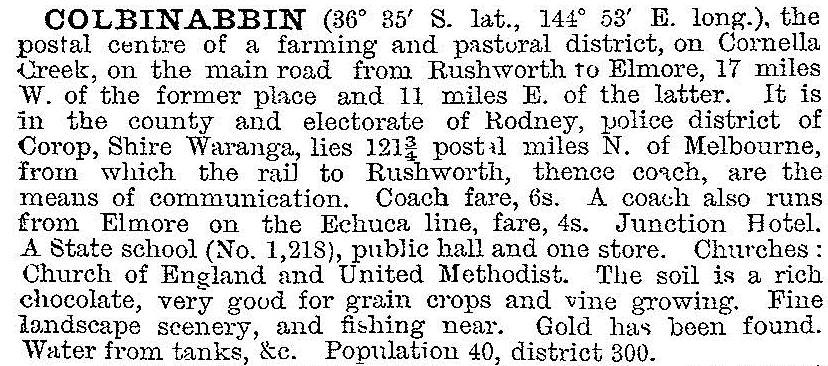
The Cornella Creek and adjoining country provided good dry farming land. Wheat harvests were high, and more settlers were attracted to the Lake Cooper area and Carag Carag to the north of Colbinabbin. In 1903 the Australian handbook described the village and its district:

Colbinabbin was situated between the two northern railway lines from Melbourne to Echuca and Melbourne to Shepparton. Agitation began in 1907 for a westerly branch railway line from Murchison, via Rushworth. Population increases had occurred in 1904 when the remaining land of the old Colbinabbin pastoral run was subdivided for closer settlement. A Rushworth and Colbinabbin Railway Trust levied rates on local properties to pay for the railway, which opened in 1914. The Colbinabbin station became a major wheat handling terminal.
Colbinabbin has maintained a range of village facilities including a school (38 pupils, 2014), a public hall, a church, stores, a hotel, a bowls club, a swimming pool and a recreation reserve. The railway line closed in 1987. A microfiltration plant was installed (2011) to improve the quality of the town's drinking water.
Colbinabbin’s census populations have been:
| area | census date | population |
|---|---|---|
| Colbinabbin | 1891 | 30 |
| 1901 | 47 | |
| 1921 | 166 | |
| 1947 | 198 | |
| 1954 | 224 | |
| 1966 | 152 | |
| 2006 | 112 | |
| Colbinabbin and environs | 2011 | 297 |
At the 2011 census farming accounted for 38.2% of employment in Colbinabbin and environs.
Further Reading
Harley Forster, Waranga 1865-1965, F.W. Cheshire, 1965
V. Isaacs and R. Whitehead, The Rushworth, Colbinabbin and Girgarre railway, Australian Railway History Society, Victorian Division, 1973
Betty Tyzzer, Colbinabbin and district 1840-2010, Colbinabbin, 2010


