
Koo Wee Rup
Situated 65 km from central Melbourne, in the Shire of Cardinia, Koo Wee Rup (Aboriginal for 'blackfish swimming'), takes its name from the fish which populated the area formerly known as 'The Great Swamp', an area of approximately 100,000 acres extending from Sawtell's Inlet in Western Port Bay to Bunyip in the north-east. The swamp, which initially formed a barrier to white settlement, was the site of one of the largest drainage schemes ever undertaken in Australia.
In 1839, Robert Jamieson and Samuel Rawson leased a run, Yallock station, which included the present site of Koo Wee Rup. In 1851 this was sold to John Bakewell, William Lyall and John Mickle. Lyall was the sole owner from 1857-72, prior to the subdivision into settlers' blocks. Lyall experimented with drainage schemes on his property Harewood Homestead. Formerly a hunting lodge, it is now a weekend tourist attraction situated near the Tooradin Airfield. The inability of personal drainage schemes of farmers such as Lyall, Duncan MacGregor and McMillan to cope with major flooding led to the foundation of the Koo Wee Rup drainage scheme which the government took over in 1893, appointing Carlo Catani as engineer in charge.
Catani commenced a Village Settlement, a scheme established by the government in 1892 to stop the drift of unemployed to Melbourne. An unemployed married man was required to take up a 20 acre block as a condition of employment. In 1898, legislation was passed to enable settlers to increase the size of the allotments in order for them to become economically viable. The district's 400 km of drains – mostly dug by hand – were completed about 1905.
The main drain was enlarged in 1916 with the aid of a German Lubecker steam dredge ordered by Catani. The Water Commission became responsible for the area in 1913 and needed to carry out extensive modifications to the drainage system in order to combat flooding. The area was subject to extensive flooding in 1924, 1934 and 1937.
In 1888, the first permanent home, The Grange (still standing, though greatly altered) was built by the Hudson family. In 1889, 35 acres were reserved for the township of Koo Wee Rup. Construction of the Great Southern Railway began in 1887 and the line to Koo Wee Rup station (formerly named Yallock) opened in 1890. The Presbyterian church building opened in 1896. Between 1901 and 1908 a Catholic church, public hall, recreation reserve, post office and telephone service were established.
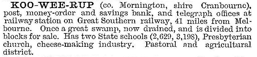
In the Australian handbook of 1903, Koo Wee Rup was described:
In 1909 the Yallock school was transferred to Koo Wee Rup. The Royal Hotel opened in 1915; the Koo Wee Rup Sun commenced publication in 1918; Amalgamated Wireless of Australia established an experimental radio station in 1921 (closed 1923); the first bush nursing hospital in Victoria was built in Koo Wee Rup in 1922; electricity supply began in 1927.
In the postwar period, the Koo Wee Rup district became Melbourne's primary supplier of vegetables and milk. Potatoes – first planted about 1890 – began to replace dairying as the major land use from the 1950s-60s as market gardeners moved to the area as part of the urban land sprawl. Asparagus overtook potatoes as the main crop in the 1990s. Asparagus growers called for an upgrade to the drainage systems in 2013. Homes in Koo Wee Rup were evacuated in the 2012 floods when the Bunyip River flooded.
In 1959 the last remaining section of the Koo Wee Rup Strzelecki railway closed. By 1971 Koo Wee Rup was a well established centre with a pre-school centre, State and Catholic primary schools, a secondary college (1957), four churches, hospital, professional services, motel and shopping centre. A swimming pool was opened in 1975. Since 1985, new housing has been constructed. The Koo Wee Rup Boat Club has moorings at the Bunyip River entrance. An historical society was formed in 1974 which is now housed at 'Mallow' (1916), former home of the pioneer O'Riordan. The railway through Koo Wee Rup to Tooradin ceased in 1993. The Koo Wee Rup to Lang Lang rail line was replaced with a rail trail in 2012.
The Koo Wee Rup primary school had 174 pupils and the secondary college had 1006 pupils in 2014.
Koo Wee Rup's census populations have been:
| area | census date | population |
|---|---|---|
| Koo Wee Rup & environs | 1911 | 652 |
| 1921 | 827 | |
| 1933 | 981 | |
| 1947 | 1135 | |
| 1954 | 1309 | |
| 1961 | 1459 | |
| Koo Wee Rup | 1966 | 1014 |
| 1991 | 1106 | |
| 2001 | 1308 | |
| 2006 | 1421 | |
| Koo Wee Rup & environs | 2011 | 3079 |
Further Reading
Berwick-Pakenham Historical Society, In the wake of the pack tracks: a history of the Shire of Berwick, now the City of Berwick and the Shire of Pakenham, 3rd ed 1994
Niel Gunson, The good country: Cranbourne Shire, 1968
Fred Hooper, The good country 'into the dawn of a new day' 1968-1988 Shire of Cranbourne, Cranbourne, 1988
D.J. Mickle, Koo Wee Rup: a brief history of 130 years 1839-1969, Koo Wee Rup and District War Memorial Swimming Committee, 1969
David J. Mickle, Mickle memories of Koo Wee Rup: for young and old volume 1 to 1927. D.J. Mickle, 1983
David J. Mickle, More Mickle memories of Koo Wee Rup Vol II: chronicles of a prosperous district once known as the Great Swamp, 1928-1940, D.J. Mickle, 1987
Merilyn Ramsay, Steam to Strzelecki: the Koo Wee Rup to McDonald's track railway, Australian Railway Historical Society Victorian Division, 1991
David Roberts, From swampland to farmland: a history of the Koo Wee Rup flood protection district, Rural Water Commission of Victoria, 1985
Koo Wee Rup Swamp entry