
Lang Lang
The township of Lang Lang, just off the South Gippsland Highway, is located about 76 km south-east of central Melbourne. It is on the southern edge of the Koo Wee Rup Swamp and south of the Lang Lang River which enters Western Port Bay.
The Bunurong tribe originally occupied the area, some remaining for many years after the Yallock pastoral run was taken up in 1839. Land selection began in 1866 and by the early 1870s a number of pioneer families were established. Swampy land was drained, cleared and cultivated and the settlers dairied, made cheese and raised pigs. A jetty at Lang Lang Beach, 6 km from the town, provided communication with Melbourne.
In the mid-1870s as selectors pushed further outwards, a village grew at the junction of the tracks to the Grantville and Poowong districts. Known as Tobin Yallock, its official name was Lang Lang, generally thought to be an Aboriginal word for clump of trees.
In 1890, the railway line from Melbourne into South Gippsland reached Lang Lang. The railway station was a mile east of the village and was named Carrington, apparently after a New South Wales governor. Gradually, settlement moved to the vicinity of the railway station, and when the store housing the post office at Tobin Yallock burnt down in 1892, the post office and name of Lang Lang was transferred to the new town. The public buildings, hall, mechanics' institute, and church, were also moved there. Tobin Yallock had a school (1875-90) and Lang Lang's school opened in 1888.
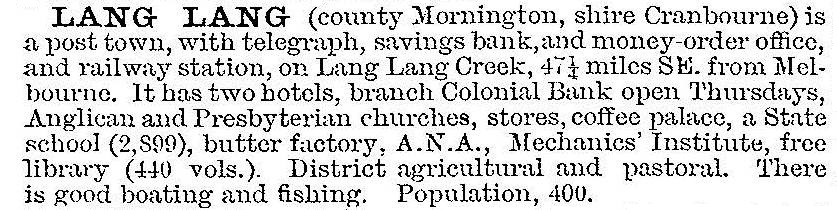
The Australian handbook described the town in 1903:
The growing town served an extensive dairying and pastoral district, including the village settlement at Yallock and the closely settled area of Yannathan. A butter factory was established in the 1890s and a busy stock market sold cattle, horses and sheep. The first agricultural show was held in 1901. In 1916, the lower two miles of the Lang Lang River were dredged to remedy frequent flooding.
Lang Lang gradually declined in importance during the pre and early postwar years, with the growth of the provincial centre of Dandenong with its larger livestock market and expanding retail services. The railway line closed in 1993 but Lang Lang remains a rural service centre with shops, hotel, police station, school (146 pupils, 2014), hall, showground, sports facilities, community centre and churches. A popular rodeo has been held annually since 1944. The Lang Lang butter factory closed in the 1940s, and the building was used for various industries, including hosiery making.
Sand is mined nearby, supplying the glass factory at Dandenong. The Holden Proving Ground, a circuit for testing new cars, was established south of Lang Lang in 1957. With Holden announcing the withdrawal of its Australian manufacturing operations by 2017, the fate of design and engineering workers at the Lang Lang plant was put in doubt. At the nearby foreshore, a saltwater swimming pool was constructed in the 1950s. There are now camping facilities, boat shed and jetty.
Census populations for Lang Lang have been:
| census date | population |
|---|---|
| 1911 | 616 |
| 1933 | 306 |
| 1954 | 419 |
| 1976 | 571 |
| 1991 | 696 |
| 1996 | 825 |
| 2006 | 921 |
| 2011 | 1345 |
Further Reading
Niel Gunson, The good country, Cranbourne Shire, Melbourne, 1968
James Leslie Ridgeway, Rodeo at Lang Lang, Lowden Publishing, 1976