
Neerim South
Neerim South is the centre of a farming district in the foothills of the Great Dividing Ranges. It is in West Gippsland, 22 km north of Warragul and 124 km east of Melbourne. According to Bunce's Language of the Aborigines of the Colony of Victoria (1859), Neerim is an Aboriginal word meaning long, not short and spear.
Neerim South is the largest of five Neerim settlements. The others are Neerim North, Neerim Junction, Neerim and Neerim East.
Gold prospectors reached this densely forested area in the early 1870s. Selectors soon followed and the first township was surveyed at Neerim, about 9 km north of Neerim South. By the 1880s there were small settlements at Neerim South and Neerim North. Neerim South consisted of several shops, a post office opened in 1883, and court house and police station opened in 1888. A school was established north of the town in 1881 (125 pupils, 2014).
A branch railway line from Warragul was proposed, to utilise the timber resources of the area. The opening of the line to Neerim South in 1892 led to the establishment of several sawmills. A steel tramline ran from two sawmills at Neerim to the station at Neerim South. Neerim South's position as rail terminus led to rapid development in the township. A mechanics' institute hall was constructed about 1898, a general store in 1900 and in 1902, a hotel, Ye King's Arms. A newspaper commenced in 1903. The Australian handbook described the progress of the district in 1903:
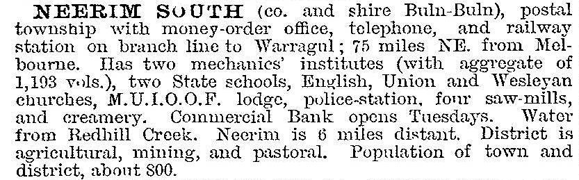
The advent of the railway also encouraged agriculture in the district. The area cleared for cultivation gradually increased, aided by the bushfires of 1898. In 1903, a butter factory commenced operations.
The Neerim East district was settled in the 1890s and had a school, church, store and hall. Neerim township did not develop, having just a cemetery, hall and recreation reserve. The Agricultural Show, first held at Neerim South in 1907, has been held at Neerim from 1979. Neerim Junction, about 13 km north of Neerim South, was a busy township by 1900. John Young Woolstencroft, storekeeper at Neerim Junction, published many of his photographs of the district as postcards from about 1907. Neerim North had a school and hall. In 1917, the railway line was extended to Nayook, east of Neerim Junction, where a small sawmilling settlement developed. In 1919, the line reached Noojee. In 1911, the population of the district, ie all five Neerims, was 1241.
The high rainfall and rich soil of the area made dairying and potato growing the main agricultural pursuits. The butter factory closed in the 1940s, and milk was transported to larger centres. A quarry at Neerim North was worked from the 1890s. The railway line was closed in 1954. In the 1960s, a reservoir was constructed on the Tarago River near Neerim South, supplying water to the Mornington Peninsula.
The main Neerim Road runs along a ridge, and as the traveller approaches Neerim South, there are stunning views to the east. The town's main street has a median with plantings and flower beds.
A hospital was first established in 1928 and a new larger facility opened in 1967. A nursing home was added in 1982. There is a small secondary college (148 pupils, 2014) established in 1960, and a community library. There is a heated outdoor swimming pool and indoor sports stadium. The hotel, hall, two churches and sports clubrooms are new modern buildings. Like all small towns, it encountered some difficulties in the 1990s, with the closure of both its banks and loss of the Conservation, Forests and Lands offices, but there are several new housing developments attracting retirees and young families. There are also many people living on small farms pursuing a country lifestyle.
Dairying, beef cattle grazing and potato growing are the mainstays of the district, but there is considerable diversification. Fruit and berries, deer and ostrich farming are well established, as well as a specialty cheese factory and vineyard and winery.
At Glen Nayook, near Neerim Junction, a forested gully has been reserved. Although it has been burnt by bushfires, it preserves the types of forest and treeferns which originally covered the area.
Census populations for Neerim South have been:
| Census Date | Population |
|---|---|
| 1901 | 288 |
| 1921 | 568 |
| 1933 | 515 |
| 1954 | 619 |
| 1966 | 468 |
| 1976 | 336 |
| 1996 | 493 |
| 2006 | 608 |
| 2011 | 1193* |
*and environs
Further Reading
D. Hunt, A history of Neerim, 1986
D. Hunt, A history of Neerim II, 1988
G. Butler, Buln Buln: a history of the Buln Buln Shire, Drouin, 1979
J.B. Swaffield, History of Neerim district, 1972
J.T. Rochford, East of Neerim, 1992
K.A. Pretty, Buln Buln to Baw Baw: a history of the Shire of Buln Buln from 1978 to 1994 and its transition into the Baw Baw Shire, 1995