Bellarine Rural City
Bellarine Rural City, an area 332 sq km, occupied about two thirds of the Bellarine Peninsula on the western side of Port Phillip Bay. Its administrative centre, Drysdale, is 55 km south-west of central Melbourne. For a physical description of the area see the entry on Bellarine.
The Bellarine Peninsula's fertile land was occupied by white settlers moving east from Geelong. After initial occupation by pastoralists there were farm subdivisions by the early 1850s. Early townships included Drysdale, Leopold and Portarlington (1851). In 1853 the Portarlington road district was proclaimed. Additional adjoining road districts (1860, 1861) were consolidated as one, approximating the boundaries of the future shire which was proclaimed in 1865. Its western and southern boundaries were Boundary Road, Geelong, and the Barwon River (following the north shoreline of Lake Connewarre and running down to Ocean Grove on Bass Strait.) Queenscliff borough was excluded. The shire was named Bellarine, thought to derive from an Aboriginal expresssion describing an elbow or resting on one's elbow.
The shire council inherited the road board's office in High Street, Drysdale, a few doors away from the Buck's Head hotel at the village crossroads. In 1880 it replaced the building with a combined shire hall and court house. The year before a railway opened from South Geelong to Queenscliff, running parallel to the coast through Leopold to Drysdale and then turning south-east to the terminus. The line's busy years were from its opening until the early 1930s and again during World War II. In addition to farm produce (fruit, onions, potatoes), the railway carried bagged Cheetham salt, bagged shell grit, and wagon loads of fish from Queenscliff. Much of the passenger traffic was visitors to Clifton Springs, Portarlington, Point Lonsdale and Queenscliff.
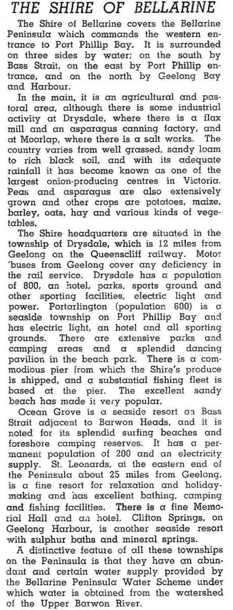
Not yet overtaken by Ocean Grove, the rural shire's largest town was Drysdale. In 1946 the shire was described in the Australian blue book:

By 1950 there was an upswing in land subdivisions in the shire, particularly near its boundary with Geelong. Ocean Grove also had a housing boom, its population nearly tripling to 1350 between 1947 and 1954. The Victorian Housing Commission built estates of 300 and 500 dwellings at Newcomb and Whittington.
The shire's population tripled during 1947-66. New shire offices were built in Drysdale in 1962, and Newcomb was connected to the Geelong sewerage system. There was industrial development in the 1960s at Point Henry with the Alcoa alumina refinery and associated pier. Water supply and road infrastructure were also built, and childcare and kindergartens opened. The Bellarine Sewerage Authority was established in 1977.
The shire's population went from 18,791 to 36,520 during 1971-86. The areas of greatest population were:
| Place | Population and % of shire's population |
|||
|---|---|---|---|---|
| 1971 | 1986 | |||
| Clifton Springs | 413 | 2.2% | 3665 | 10.0% |
| Leopold | 1454 | 7.7% | 3452 | 9.5% |
| Newcomb | 5994 | 31.9% | 4979 | 13.6% |
| Ocean Grove | 3022 | 16.1% | 7034 | 19.3% |
| Whittington | 2361 | 12.6% | 6145 | 16.8% |
| 13,244 | 70.5% | 25,275 | 69.2% | |
While managing the population growth the shire council also had to provide camping facilities at popular seaside places such as Portarlington and Ocean Grove. Even Indented Head and St Leonards populations (550) swelled fourteen-fold during peak camping times.
In 1989 Bellarine Shire was restyled Bellarine Rural City as its population surpassed 40,000. Even that rate of growth did not stem the trend to municipal amalgamations. On 18 May 1993 Bellarine Rural City was united with Geelong, Geelong West and Newtown cities, Corio and South Barwon Shires and parts of Bannockburn and Barrabool Shires to become Greater Geelong city.
Bellarine Shire/rural city's census populations were:
| census date | population |
|---|---|
| 1871 | 3802 |
| 1881 | 4098 |
| 1891 | 4911 |
| 1901 | 4601 |
| 1911 | 4262 |
| 1933 | 3845 |
| 1947 | 4069 |
| 1954 | 7015 |
| 1961 | 10,127 |
| 1966 | 14,523 |
| 1971 | 18,791 |
| 1976 | 25,230 |
| 1981 | 31,380 |
| 1986 | 36,520 |
| 1991 | 43,620 |
Further Reading
Ian Wynd, Balla-wein: a history of the Shire of Bellarine, Drysdale, 1988, 2005
Bellarine heritage study, Deakin University, 1996
Bellarine, Clifton Springs, Drysdale, Indented Head, Leopold, Moolap, Newcomb, Ocean Grove, Portarlington, St Albans Park, St Leonards, Wallington and Whittington entries


