
Glenmaggie District
The Glenmaggie district is in the Macalister River valley in Gippsland, 10 km north of Heyfield and 160 km east of Melbourne.
In 1851 Malcolm MacFarlane took up the Heyfield pastoral run, an area of more than 61,000 acres. Eight years later it was subdivided, the second part being named Glenmaggie. It is thought that the name was bestowed by another Scots pioneer, Angus McMillan, in memory of Margaret McKinnon from his boyhood days. In 1866 gold was discovered in the area, and by the 1870s farm selectors came to settle there.
Glenmaggie
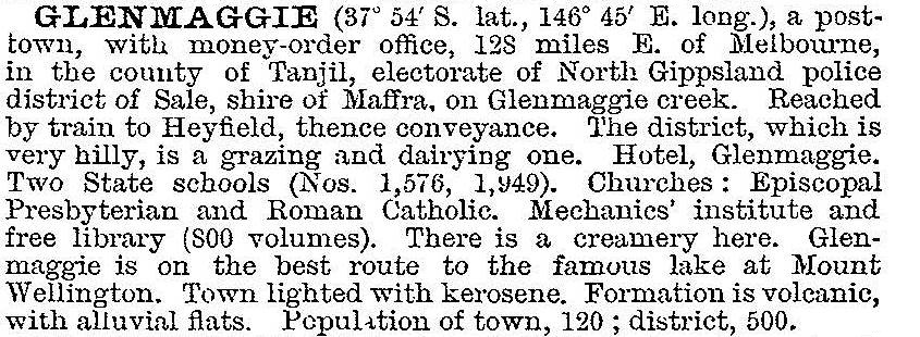
A post office opened in Glenmaggie in 1872 and a school, named for its first ten years as Gower Bridge, opened in 1875. Catholic, Anglican and Presbyterian churches opened in 1878, 1882 and 1884. The valley's fertile river flats grew cereals and vegetables; wheat was milled at Heyfield, most farms had pigs and dairy cattle, and the creamery evolved into a milk depot for a dairy factory at Heyfield. In 1903 Glenmaggie was described in the Australian handbook:
In the 1910s farmers downstream towards Maffra began to agitate for a weir on the Macalister River, both for flood mitigation and irrigation for crops (sugar beet, maize, lucerne). The State Rivers and Water Supply Commission built a weir at Glenmaggie, completing it in 1927. Much of the town was flooded, although the mechanics' institute (1890), Catholic church and the school were moved to higher ground. The Weir primary school operated during 1921-28 for children of the workers. The storage was enlarged in 1957, taking most of the remaining good farm land.
The local economy changed from milk and vegetables to boats and caravan parks. There are also several holiday houses: on census night in 2011 nearly half the houses were unoccupied in Glenmaggie and the surrounding area. There is a boat club and south of the village are several boat ramps.
Lake Glenmaggie's submerged area is 17.6 sq km and its storage capacity is 190,000 mega litres. Its catchment area of 1891 sq km reaches to 20 km south of Mount Buller. The main irrigation channels from Lake Glenmaggie are northern (1929) to Newry and Boisdale and southern (1955) to Nambrok/Denison. Hydro powered electricity turbines were installed in 1994.
Bark House days by Mary Fullerton (1868-1946) is set in Glenmaggie.
Coongulla
On the lake's northern shoreline there is the holiday and retirment settlement of Coongulla. It has a caravan park and a CFA station. On census night in 2011 65% of the dwellings were unoccupied.
Seaton
West of Glenmaggie there was a track to the Jordan/Woods Point gold fields with a stopping place at a spot known as Bald Hills. It was settled by Europeans in the 1860s, with a post office (1862) and a school (1866). The post office was renamed Seaton in 1879, continuing until 1969. The school, however, operated intermittently, closing in 1944. Seaton has a public hall and a CFA station. Bushfires swept through the area in 2006 and again in 2013.
Dawson
South of Seaton there is the locality of Dawson. Its school operated for only a few years (1888-91), but it had a post office (1888-1958) and a stopping place on the railway line from Traralgon to Maffra.
Census populations have been:
| census date | population | ||
|---|---|---|---|
| Glenmaggie | Coongulla | Seaton and Dawson | |
| 1911 | 310 | - | - |
| 1921 | 458* | - | 98 |
| 1947 | 163 | - | - |
| 1961 | 97 | - | - |
| 2011** | 289 | 297 | 215 |
*including 164 at Weir, ** including environs
Further Reading
Minnie Higgins and Linda Barraclough, Glenmaggie to Glencairn: our valley remembered, Bairnsdale, 1998
Betty Chester, Glenmaggie school 1576, centenary year 1875-1975, 1975
Linda Barraclough and Minnie Higgins, A valley of glens, Bairnsdale, 1986