Wahgunyah
Wahgunyah, on the south-east side of the Murray River, is 235 km north-east of Melbourne. The nearest medium size Victorian town to it is Rutherglen, about 8 km to the south-east.
The name came from the Wahgunyah pastoral run taken up in about 1841 by John Foord and John Crisp. The run extended from the Murray River, southwards to Black Dog Creek, occupying about 13,800 hectares. ‘Wahgunyah’ is thought to be an Aboriginal word for big camp. In 1853 Foord purchased half a square mile of his holding, on the south-east bank of the river, and three years later had it surveyed for a township. The Wahgunyah Hotel was opened in 1856.
Foord installed a punt across the river in 1857 and built a flour mill at Wahgunyah in 1858. (The mill operated until 1941 and was burnt down in 1956.) Foord replaced the punt with a toll bridge and went on to be known by locals as the Emperor of Wahgunyah. A school was opened in 1858 and a police station in 1859. Wahgunyah was reached by a river boat in 1853 and became a river port for the district. The discovery of gold at Rutherglen (first called Wahgunyah Rush) in 1860 brought population and increased river trade. Boats from Wahgunyah carried goods and passengers to Echuca (for connecting rail service to Melbourne when the line was opened in 1864), and beyond Echuca to South Australia.
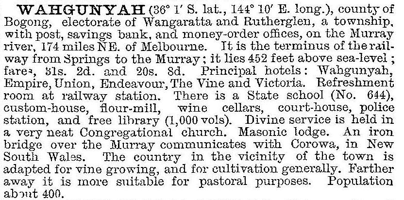
Despite Wahgunyah's transport function, it was overtaken by Rutherglen and Chiltern because of their goldmining, viticulture and subsequent direct railway connection with Melbourne and Wodonga (1873). A branch line from Springhurst to Wahgunyah was opened in 1879. In 1903 the Australian handbook described Wahgunyah:

The wine cellars mentioned in 1903 are All Saints and St Leonards. The All Saints Winery was begun by George Sutherland Smith in 1864 on sandy river flats 2 km north of Wahgunyah. The winery is surrounded with turreted castle walls (1880) and is on the Australian and Victorian historic buildings registers. St Leonards winery (1866) is also adjacent to the river.
Wahgunyah's population increased during the 1980s. It has a primary school (84 pupils, 2014), two churches, a public hall, the Uncle Tobys food processing factory, grain sheds, a hotel, two motels, sports clubs and Lake Moodemere, 4 km to the south. A customs house (1886) in Foord Street is on both historic buildings registers. Wahgunyah was the terminus of a railway line, confined to freight until 1995 when the service was suspended. It is joined by bridge to Corowa, a larger town with the advantage of poker machines until the machines were introduced to Victoria in the early 1990s.
Wahgunyah's census populations have been:
| Census date | Population |
|---|---|
| 1861 | 225 |
| 1881 | 452 |
| 1891 | 809 |
| 1901 | 471 |
| 1921 | 598 |
| 1933 | 596 |
| 1947 | 478 |
| 1954 | 508 |
| 1961 | 470 |
| 2006 | 809 |
| 2011 | 891 |
At the 2011 census, grain/cereal processing accounted for 8.4% of employment, with food and meat processing 11.5% and livestock farming 4.6%.
Further Reading
Muriel McGivern, Big camp Wahgunyah: history of the Rutherglen District, Spectrum Publications, 1983


