Wandiligong
Wandiligong, a rural township in north-east Victoria, is situated on a tributary of the Ovens River and is 75 km south-east of Wangaratta. It was named after the Wondillegong pastoral run which was taken up by William Forlonge in 1845. It is thought that the name was derived from an Aboriginal word describing a spirit.
The name of the tributary is Morses Creek, which is joined by Growlers Creek opposite the Wandiligong primary school. In 1856-58 gold was discovered near the junction of the two creeks, and the settlement that formed was known as Growlers Creek until 1872 when it was named Wandiligong.
The settlement was based on various profitable reefs and several hundred people settled there. A school was opened in 1860 along with Catholic and Methodist churches. Presbyterian and Anglican churches were opened later in the decade. An athenaeum (1870) and a hall for the Manchester Unity Independent Order of Oddfellows (1874) were also opened. The population of Wandiligong was maintained at over 1000 people until the 1880s and the pressure of pupils on the school accommodation led to the building of an elaborate brick building with an imposing bell tower in 1877. It is Wandiligong's most imposing building and is on the Victorian Heritage Register. A sports reserve now known as Alpine Park was laid out in the 1870s.
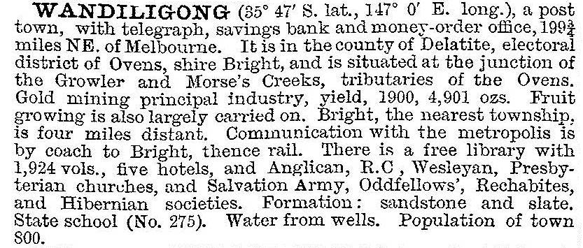
Reef and deep lead mining continued until the 1900s. The narrow valley in which the town is situated was increasingly used for orcharding, hops, tobacco and nut groves, and the Wandiligong Horticultural Show became an important annual event during the 1880s. In 1903 Wandiligong was described in the Australian handbook:

At around 1900 two further elements intruded. Exotic trees were planted – notably avenues of poplars – and Growlers Creek became a site for gold dredging. Whereas the trees enhanced landscape quality, the dredging consumed valuable alluvial flats and left a denuded riverbank landscape. An anti-dredging league obtained some concessions to dredging damage, but the industry continued until about 1930. Timber was consumed for mine props and dredge fuel, and in about 1917 pine plantations were established on dredge tailings and the lower hill elevations.
When dredging ended, Wandiligong's population declined, abetted by the railway line only coming as far as Bright, 8 km downstream.
During the 1960s the Anglican and Catholic churches held their last services (the Presbyterian church had closed in 1924), and the town was left with a number of decaying buildings, little used but remembered with affection. When the brick oddfellows hall was in danger of demolition in 1972 the Wandiligong Preservation Society was formed. The Society has preserved and found uses for the hall and the Anglican church, and participated in the planning of landscape controls over the Morses Creek valley and the township.
Wandiligong is situated in a valley with numerous views and an intimate scale. It has a scattered array of houses interspersed with native and exotic trees. There is a hotel, a caravan park, a school (43 pupils, 2014), a Uniting church and a public hall. There is a signed walk which takes in the main street, former mine areas, dredge tailings, and the Alpine Park.
The Wandiligong Town Framework Plan was produced in 2006 and revised in 2009 and reflected an emphasis on the heritage overlay, a pathway beween the town and Bright, and enhancemnet of the diggings site.
Wandiligong's census populations have been:
| Census date | Population |
|---|---|
| 1881 | 1105 |
| 1891 | 670 |
| 1921 | 407 |
| 1947 | 238 |
| 1966 | 132 |
| 2006 | 281 |
| 2011 | 296 |
Further Reading
Bet Moore, 'Nothing Worth Saving': a history of the Wandiligong Preservation Society, 1972-2005, Wandiligong, 2005
Brian Lloyd and Kathy Nunn, Bright gold: the story of the people and gold at Bright and Wandiligong, Brighton East, 1987
Wandiligong: a valley through time, Wandiligong Preservation Society, 1988


